Photo Album #1 | Photo Album #2
Sat 10th
⁃ Get thru hiker permit from Katahdin Stream Campground
⁃ Camp at Katahdin Stream Campground
Tomorrow, I hike up Katahdin to reach Baxter Peak, the northern terminus of the Appalachian Trail. Assuming it goes well, I’ll continue south, and, with any luck, eventually reach Springer Mountain.
While there’s I’ve done a lot of preparation, I’m sure there’s much more I’ll learn along the way. For example, I only just learned the correct way to pronounce Katahdin: initially I’d been pronouncing it like Katadyn (the water filter brand), but it’s actually pronounced Ka-TAH-din, with the TAH like TAHoe. On the subject of preparation, I’ve managed to get my base weight down to ~18 lbs (lighterpack), with 4 lbs of that being camera gear (Sony A7C, Sony G 20 mm f/1.8, Sigma Art 105 mm f/2.8 Macro, Peak Design Capture Clip). I’m prepared to trade the camera for just using my phone alongside a macro lens if I decide it’s not worth the weight after hiking Katahdin, but I’m really hoping I can keep it. Even excluding camera gear, I have no idea how the ultralight crowd manages to get to sub-ten pound base weights; I’m not sure I could remove much more stuff from my bag, nor further lighten the stuff still in my bag.
I made a few last-minute gear changes to help lighten my bag. First, I switched from a freestanding tent, the NEMO Hornet OSMO 2P, to a trekking pole tent, The One by Gossamer Gear. And yes, that does mean I am carrying—and I guess using—trekking poles. I’ve never personally been a huge fan of trekking poles. Much like high ankle boots, I know some people swear by trekking poles and can’t hardly hike without them. For me, I’ve always been a proponent of watching where you step, ensuring my legs are strong enough to always maintain balance, and ensuring ankle strength and range of motion to prevent ever rolling my ankles. However, the thing that finally convinced me to try them out was the multitude of stream and river crossings on the trail, where they might help keep my feet (and myself) dry by helping maintain balance while rock hopping or crossing log bridges. And at a minimum, I can use them as tent poles and carry a lighter tent!
Back to the topic of tents, I absolutely love both of my tent options. The Hornet is magically light, packs down impressively small, is up impressively fast, is super roomy inside, and even has two side doors and vestibules (side doors are a feature I love from my NEMO Galaxi 2P and one I could never give up). So, if you’re on the market for a (semi) freestanding cozy 2 person/spacious 1 person tent, you can’t go wrong with that one—and rumor has it, the Mechanicsburg REI has one as a used garage sale item (hmm, I wonder where that came from…) It did hurt to part with it, but it hardly makes sense to keep a tent that’s squarely between my car-camping and UL backpacking tents), so I guess it can go to someone else who will use (and abuse) it more than I would. Now, as for the tent it was replaced by, The One offers what I’ll call “surprisingly large amounts floor and ceiling space for a one person tent”; Ie, room for one, plus a bit of stuff next to your feet—or (as I’ve heard described) two people if they’re sharing a one person sleeping bag and pad—and enough space to comfortably sit up in the center of the tent. It doesn’t roll up as tightly as the Hornet, but it does seem quite packable. It’s also a single-wall tent, so ventilation and condensation are more of an issue. It also requires at least 6 stakes, so it’ll probably suck to set up on a gravel tent pad (or a tent pad with gravel underneath…). And there’s no space for my pack or shoes inside, so they’ll have to go under the vestibule (eew, bugs and runoff). Oh, did I mention I haven’t actually slept in this tent yet? I’ve set it up to treat it (and the rest of my gear) with permethrin, but haven’t actually slept in it yet, so hopefully it won’t suck?
One nice thing about a trekking pole tent, once you’ve learned how to put it up, it’s pretty fast to set up. For this one, just stale out the 4 corners at a 45 degree angle, then put the back pole in and stale that side out, then repeat with the front pole, and finally, go around and tighten the cords until the fabric is taught.
After setting up our tents, my parents and I had dinner (note to self: jetboils boil water quickly; don’t leave them unattended and full of ravioli, unless you want pasta water everywhere), then finished the night with a round of cribbage (hopefully my victory bodes well for the hike tomorrow…).
Sun 11th
⁃ Hike to Baxter Peak and back (8 mi)
⁃ Camp at Katahdin Stream Campground
Today’s the day! While Baxter offers daypacks for AT hikers to use for summiting Katahdin (not to mention I have my open day pack I have as well), I want to get a better feel for how heavy my pack is while my parents are still around (to pawn gear off on).
I largely refuse to set alarms while camping or backpacking, and ended up sleeping in till around 8:30 AM, when I got up, made breakfast, relocated several banana slugs that wanted to move in with me, rolled up my tent, packed up my entire bag (minus my tent stakes (I think I can handle an extra ounce or so, and I don’t have to worry about putting them back into the same rocky ground they already were in). Once I was packed, we headed over to the Katahdin Stream Campground from where we were camping at Foster Field (there were only these group sites and a few lean-tos still available at Katahdin Stream Campground).
Based on what I read on the Baxter State Park website (which I’ll note is not actually a Maine State Park, but rather a land trust left by a former governor), before summiting Katahdin, I’m supposed to obtain an AT hiker permit from the ranger station. First problem: where is the ranger station? We ask a random group of day hikers, who attempt to give us directions to the park entrance gatehouse (lol). Eventually, we managed to find a campground map, and managed to find our way to the ranger station. But we have another problem: the office is only open 8-9 AM and 5-6 PM. It’s now 10:30 AM. Well, I tried to get a permit. Guess I’ll just hike Katahdin and deal with getting a permit later, maybe even have my parents grab it while I’m hiking.
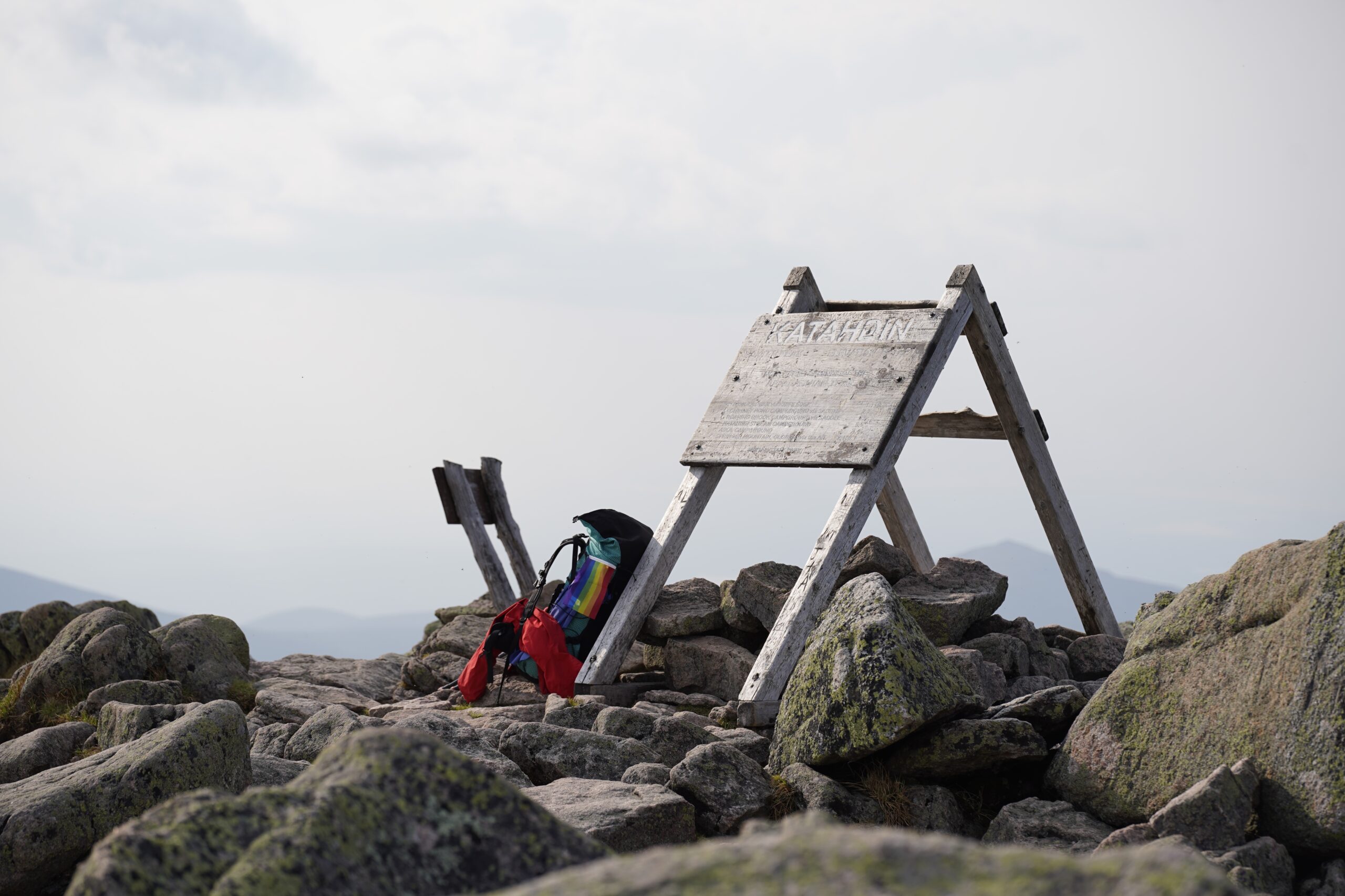
The trail up starts out pretty flat, with some mud, roots, and rocks occasionally interrupting the otherwise well maintained trail. However, soon after passing the junction for the Owl Trail and the Katahdin Stream Falls bridge, the trail slowly becomes steeper and steeper, then begins to have streams weave their way through the trail, and we start to get some light (nontechnical) rock scrambling, all while overtop of a stream running through the trail. Nonetheless, the hike up is beautiful, and lost track of time and spent about half an hour taking pictures at and around the falls. Continuing up the trail, however, as one commenter on FarOut (a map/guidebook/communication platform for hikers) put it, “the bouldering begins just past here, before it goes cray-cray above treeline.” It does indeed go cray-cray above treeline. While the stream-trail hybrid is gone, above treeline, we quickly get to more aggressive rock scrambling, and as we approach the top of the ridgeline, some straight up bouldering. Though most of it remains nontechnical, I’m appreciating all the balance and grip practice I’ve had from past climbing experience, especially with having a full backpack on my back. What I wasn’t appreciating, though, was the muscle cramps I was starting to halfway up the scrambling/bouldering section, and decided to take an early lunch/drink break. Thankfully, after lunch, a Liquid IV (think gatorade), ~1.25 L water, and some stretches, I was mostly feeling better, and continued on, with the cramps eventually going away after about an hour. As I was going up the ridgeline, a group of guys was coming down and remarked, “you’re almost at the flat part.” Yeah, sure…I doubt there’s a flat part between here and the peak—there certainly doesn’t look to be one from the pictures or the relief model at the ranger station—but there was indeed a flat tablelands on top, and my legs were definitely grateful for them. Similarly, my throat was grateful for the water from Thoreau Spring since I was rather low on water at this point, having failed to fill up at any of the streams below treeline. The final stretch up to Baxter Peak from the tablelands was thankfully a more shorter and gradual version of the previous scramble. Much to my suprise, upon reaching the top, I had the summit all to myself. After dropping my pack by the infamous A-frame KATAHDIN sign and resting for a bit, I wandered around and took in the views from the summit. Afterwards, I propped my camera on a rock and set up for the obligatory photo next to (and also on top of) the sign. I’m officially hiking on the AT now!
Summiting took a lot longer than I expected (thanks to taking photos along the way, the difficult terrain, and the bad leg cramps), with me only reaching Baxter Peak at ~5:00, so I did my best to (safely) make it down to the bottom as quickly as possible, since my parents were expecting me back by 8:00 at the latest (which, shocker, was a wildly optimistic estimate, even initially). Even with a satellite communicator, it’s no use if the person you’re hoping to message doesn’t have service or their own satellite communicator, so there was no way to let them know I’d be running late. Thankfully, I managed to make it below treeline well before sunset (though I did take a wrong turn while bouldering and had to take an interesting and rather challenging way down for a while as a result). I was even able to make it about halfway to the falls before needing my headlamp. Once at the falls, though, I did take a pit stop at the first privy on the trail to take care of some business. After that was finished, however, I booked it down the trail, heading towards the campground, in hopes of finding a very late dinner waiting for me, instead of a search party being launched to find me.
Thankfully, it was the former rather than the latter, though I did hear that the ranger radioed to see if I came down the Abol Trail instead of the AT/ Hunt Trail, which I appreciate, along with the ranger assuring my parents that I was probably fine and 😜🥲was just running a bit slow (which was…entirely accurate). After dropping my bag off at the car, my dad and I went to go see if the ranger was still awake and let him know I was down safely. He was, and we chatted while going through filling out that permit i was supposed to have earlier (he was super chill about it, and said the ranger is still around outside those posted hours, just that those are the times he commits to being in the office instead doing other things around the area. Pete, the ranger we talked to that night, is a fellow Eagle Scout and offered an especially good piece of advice: don’t set any speed records, instead take the opportunity to explore the spur trails and take it all in. He also echoed the advice I’ve heard from many others to record the journey to be able to share the experience with others and be able to better remember years into the future. His final remark was, “Katahdin was the hardest thing you’ll do for the next week; the greatest hurdles you’ll face are mental, rain and bugs.” I think to myself, “neither of those seem too terribly hard to deal with, but we’ll see.”
Mon 12th
⁃ Hike 10 mi
⁃ Camp at Abol Bridge Campground
After the trail makes its way down Katahdin, it weaves through several lakes and streams in the southern end of Baxter State Park, and offers numerous views of Katahdin as the trail leads away from it.
As my parents were dropping me off where I finished hiking the night before, we were met by a fellow SOBO thru-hiker, Ben, and his family, who asked if it’d be alright if he joined me for the day. Of course I obliged; I can’t complain about some company on the trail. As a fellow recent college graduate, we discussed our future plans, the atmosphere of each of our small schools, and how we both ended up as thru-hikers. We sympathized with each other on having a balance between hiking alone and hiking together, but both generally agreed we prefer smaller groups of up to 5–6 people at most. While we began together at Katahdin Stream, we didn’t make a point of staying together and met up and split apart several times throughout the day, until we met back up about a mile before Abol Bridge, as we were passing through an area burned by a wildfire just a few years ago. It was impressive just how different the area was from the rest of the forest. First, it was surprising how quickly the area had recovered, and was already blanketed in a fresh, full layer of green. Second, how much brighter and open it was with the lack of the tree canopy above. And finally, how the plant life varied from the unburied section, with many birch and brush-like plants covering the area.
We ended up splitting off after we made it to Abol Bridge, with him planning to continue about 3 miles further to Hurd Brook Lean-To, the first shelter on the trail, just inside the 100 mile wilderness, while I was staying at the Abol Bridge Campground for the night, along with my last shower and prepared breakfast for the next 10 days.
Tues 13th
⁃ Hike 11 mi
⁃ Camp Rainbow Lake Dam
Perhaps it was the feeling of relief after using the privy. Or perhaps it was the older hiker I met while walking down to the spring. Maybe it was the picturesque view of the lake from the small cove. Or the cold, refreshing flow of fresh spring water. Was it the the long break after a long day of hiking? Could it have been the anticipation of the dinner and rest I would enjoy when I made it to the campsite?
No matter what the tipping point really was, the result was a welling up of emotions. I was reminded that life is short. So to live life to the fullest, I have to live fast and live big, while I still can. As the tears welled up, I was reminded how tenuous the balance is between nature and mankind. Thinking about where I am as I walk through the 100 Mile Wilderness, I’m reminded of how little of the world’s environment remains untouched by civilization. From the crisscrossing of highways, power lines, and pipelines across forests, fields, and deserts; to the highly trafficked national parks replete with their boardwalks and interpretive exhibits scattering the landscape; to the ocean floor, with undersea cables, mines, and shipwrecks; and even to space with satellites, interplanetary probes, and countless pieces of space junk left from our past. And now, to the climate and atmosphere, with rising CO2 levels leading to to changes in climate across the globe. As humans, we pride ourselves in adapting our environments to suit our needs. However, all too often, we fail to consider how we can adapt ourselves to suit the environment’s needs.
—
I have mixed feelings on the Abol Bridge Campground, and I’m not sure I’d stay there again. While on one hand, I enjoyed the shower, ate more than my fair share of pancakes, french toast sticks, and sausage for breakfast, and enjoyed the view of Katahdin. On the other hand, it was pretty expensive ($25/night/person), the sites offered essentially no privacy from the other sites (ie, it was largely an open field), they recommended not drinking the water, and the breakfast was, at best, what I’ll describe as “functional”. And finally, Abol Pines, a state-run campground is just down the street, which, while lacking a shower and breakfast, is about half the cost ($13/night/person). Was the shower and “functional” breakfast worth $12? I don’t know. Or, would it have just made sense to just continue down the trail to the Hurd Brook shelter? Again, I don’t know.
After leaving Abol Bridge, I chatted with CJ, an AT Ridgerunner, while he was at the entrance of the 100 mile wilderness. We chatted about gear, food supplies, and my planned food drop for a bit, before wishing me well and warning me about a few downed trees and a lot of mud I’d soon run into (I thought I already ran into a lot of mud.
He wasn’t kidding. It felt like half the trail was some form of mud, and the other half was an even split of rocks, roots, and streams running through the trail. Despite that, the trail was overall quite well maintained, all things considered. Additionally, the variety of terrain it passes through is quite beautiful. Some sections were pine forest as far as the eye could see, which, felt surprisingly surreal compared to the typical variation in plants you’d otherwise see in a forest.
I stopped for lunch at the Hurd Brook Lean-To and met CJ as he was coming to the shelter after brush clearing the trail between the trailhead and the shelter and I was continuing on down the trail.
After lunch, it was even more mud, rocks, and roots as I headed towards the Rainbow Spring Campground, where initially planned to stay the night. However, I ended up arriving at Rainbow Spring early and got finished with my privy stop, water refill, and picture taking pretty quickly. While glancing at FarOut, I saw there were a few good tent spots a few miles south at the Rainbow Lake Dam, and decided to head there to stay the night instead.
All
Wed 14th
⁃ Hike 10 miles
⁃ Camp Wadleigh Stream Lean-To
“Who just tosses a can of bear spray into the woods!?” I though to myself when I found a full size can of bear spray, a holster for bear spray, and a mini can of bear spray perfectly placed on a log when I was finding a place to pee before turning in for the night. It seemed like they’d been there for a while, since the labels were faded and the fabric holster had moss growing on it. Initially, I left them where they were, and internally thought whether I was willing to carry them the next 40 or so miles to be properly disposed, or whether to leave them there or in the shelter for someone else to deal with.
In the end, Noel’s prevailed and I ended up grabbing it, along with a bit of other random trash left around the shelter and plan to toss it when I get my food drop later on.
Thurs 15th
⁃ Hike 11 miles
⁃ Camp Antlers Campsite
There’s definitely a hierarchy of privies.
First, we have the “box with a toilet seat (lid sold separately)”, as demonstrated by the Rainbow Lake Dam. It’s generous to even call this a privy, as (1) there is no privacy in its use, (2) using it is probably worse than just digging a cat hole and using that instead, since, at least in the Rainbow Lake Dam privy’s case, it seems like whenever the privy got full, they just moved the box somewhere else and just left a pile of waste behind.
Second, we have the cold, dark privy that reeks of ammonia, as demonstrated by the Rainbow Stream Lean-To’s privy. Somehow, this is even worse than the previous kind, since you at least get fresh air and light with that one.
Next, you have the luxury bathroom privy, like the Nahmakanta Lake Privy. It’s light, it’s airy, it has toilet paper, hand sanitizer, and cute little cubbies for your stuff. And while the designers did an amazing job making a privy that’d be right at home at home, they didn’t consider it’d be placed in the woods, where there are lots of mosquitoes. So there’s no bug screens on the openings up top, so you get mosquito bites everywhere that’s normally covered up.
Perhaps my favorite this far, however, is what I’ll call the “shiny new ADA compliant MATC privy”, like the Nahmakanta Stream Lean-To privy. It’s got a ramp, has grab handles, and seems like it has room for a wheelchair to turn around in (but is placed in the middle of the woods on a very non accessible trail?). It smells like fresh lumber, is light and airy, has hand sanitizer, and has great privy reading material on how a moldering privy works.
The typical privy, though is much more mundane. There’s some good parts (TP, hand sanitizer, privy design humor, lighting, airflow, privy reading material aka a trail register, mosquito screening) and some bad parts (mosquitos, spiders as big as your hand, a full privy, weird smells, barely functional latches). Overall though, for the most part the privies are fine. Occasionally you’ll get a bad one, but you’ll also occasionally get a great one. Almost always though, it’s better than having to use a cat hole.
—
I was up late tonight and had to pee, so once I came back, I decided to try a bit of nighttime long exposure/astro-photography. Since I’m not carrying a tripod, I had to improvise with a tree and a rock to prop up the camera. I’m not sure if any of them turned out any good, but it was at least fun to try.
Fri 16th
⁃ Hike 11 miles
⁃ Camp south of Crawford Pond Outlet
Ugh. I don’t like fording streams. Soon after leaving the beautiful Antlers Campsite, I had to cross the outlet of Mud Pond, which is unbridged and (at least when I crossed) not rock hoppable. Since it was such a narrow stream, and I could see all the rocks I would be walking on, I decided to eschew the advice of fording with your shoes on, and instead decided to cross barefoot. It ended up working quite well, and thanks to FarOut I knew there were actually two branches I had to cross, so I kept my shoes off till I crossed the second one.
The plan for today was to make it to at least the Cooper Brook Lean-To, then either pick up my food drop at Johnston Pond/B Pond Road today, and continue on to the East Branch Lean-To, or stop at Cooper Brook or Crawford Pond and pick it up tomorrow. With the sounds of thunderstorms in the distance (and I didn’t want to get caught on top of Little Boardman Mountain in the middle of a thunderstorm, I decided to stop at Crawford Pond and found a good tent site away far enough from the pond (as camping on the shore of the pond is apparently prohibited). Thankfully it didn’t end up raining that evening, and I was able to set up my tent and get an early rest in.
Sat 17th
⁃ Hike 1 mile
⁃ Pick up Food drop: Johnston Road/Kakadijo B-Pond Road
⁃ hike 8 mi
⁃ Camp Logan Brook lean-to
“What doesn’t kill you makes you stronger,” is how I could summarize today. I hiked through the rain with soaking wet feet, I forded a river, and I am sleeping in my first shelter tonight, braving the mice and forced social interaction in exchange for a dry place to sleep and roof that’s not made of nylon.
—
While the last three days have had forecasts or scattered PM showers and a few sounds of distant thunderstorms, none of them ever materialized, and I was graced with beautiful blue skies throughout my time on trail thus far. At least until very early this morning, when I woke to rain hitting my tent. Like anyone, I hoped it’d be gone by morning and did my best to fall back asleep.
Sadly, I wasn’t lucky enough to wish the rain away by the time I got up at around 8:30, and the inReach said it’d continue to rain for the next 24 hours straight. Great. Oh, and I have a river I need to cross today. Hindsight is 20/20, but I probably should have pushed on past the river crossing (and to the shelter on the other side) last night rather than taking an early bedtime.
To add insult to injury, I also woke up with the need to poop. So, our into the woods with a shovel, toilet paper, and a desire to go back to bed, I ventured out in search of greener pastures—no, wait that’s not it—actually just a good spot that’s hidden from the trail to dig a cat hole and do my business.
With that out of the way, and a good thorough hand washing once I was back, I made myself brunch and set about packing up for a river crossing and a hike through the rain. As typical, the sleeping bag, liner, and pillow go into the dry bag, joining my sweater and extra pair of socks. With today being a heavy rain day, though, the camera and extra lens were thrown in as well (not to mention the eventual river crossing). How the rest of my bag was packed did differ however, with my bear bag being rolled up and strapped to the outside (after the water it had accumulated was dumped out), my food bag was put on top for easy access when I get to the food drop, and the rest of the miscellaneous items shoved where the food bag would normally be, ie vertical next to the dry bag at the bottom of the pack.
As one would expect, the trail was significantly more muddy. However, the stream—sorry, the trail—was pooling with water in many places, that I pretty quickly realized it would be a waste of time to even attempt to keep my feet dry, especially with the soak through of the rain, not to mention the puddles. And, I knew I’d just be prolonging the inevitable, since I’d be fording a river with my shoes on later that day anyway.
So, just like doing a cannonball into the pool rather than gradually easing myself in, I planted my foot squarely into the middle of the next puddle. And then did the same with the next puddle and the other foot.
Surprisingly, it actually felt pretty good, almost like an ice bath on my tired feet. Combined with the rain discouraging taking breaks and some good power walking music, my hiking pace actually increased, as I was no longer carefully dodging puddles, and instead just walking straight through.
Needless to say, with the rain, there was no view from Little Boardman Mountain, nor in many of the other vistas along the trail. However, true to its name when passing by Mountain View Pond, I did manage to snap a picture of the view across the pond of some trees in the fog, and even took a few on my camera (sadly having to unpack my entire bag in the process). It was at this time I also moved my small water resistant bag of misc items into the true dry bag, along with my still dry towel, sleep clothes, and headphones (goodbye music, you served me well) (I might’ve initially forgotten to put these in, so I might’ve had to unpack my bag again, right after packing it).
After Mountain View Pond, however, my sights were set squarely on making it across the river. Upon reaching the river, I was greeted by an underwater bog bridge and about 40 feet of heavily flooded (calf deep to knee deep) trail.
After crossing, I thought to myself, “wow that was an easy river ford!” As I found out just minutes later, that wasn’t the river ford. The actual river ford was much, much more challenging. Note to self: plan your river fords based on the weather, and try to push past them if the weather isn’t bad yet.
I take back everything I said in the past about being hesitant about trekking poles. They were genuinely indispensable for getting across that river safely and without going swimming. However, that’s not to say I didn’t get quite wet (mostly knee deep, but there was a spot where I ended up almost waist deep.
After clearing the river, I took a breather and headed towards the nearby shelter, and met with a pair of hikers who’d passed me earlier in the day. The three of us, Dr. Katahdin, Wetsuit, and I, were all thankful to have space in a shelter to sleep through the rain that night. Both of them were finishing the last few sections of Maine they’d both missed when their thru-hikes were cut short in 2021. When the discussion shifted to trail magic, and they’d asked whether I’d revived any yet, and I answered no, they offered up a chocolate cookie, as “the first of many trail magics you’ll receive along the way.”
Sun 18th
⁃ hike 9 mi
⁃ Camp Carl newhall lean to
Called to book pleasant river campsite from top of whitecap. Water is up to 48” in some places
Mon 19th
⁃ Hike 5 mi
⁃ Explore Gulf Hagas/The Hermitage Loop Trail
⁃ Camp Pleasant River #10
“So, uh, are there supposed to be human bones here?” I thought as I discovered an incomplete set of human bones in The Hermitage.
—
Hot take for the day: Gulf Hagas is interesting, but it ain’t that special.
Tues 20th
⁃ Hike 12 mi
⁃ Camp Cloud Pond Lean-To
Hiking in the Chairbacks is surreal—you’re simultaneously on top of a mountain while also in a mystical forest. Seeing cloud pond is entirely worth the 0.3 mile side trail, and I am wishing I had known better and camped here like I did at Antlers Campsite. After a privy stop, I accidentally spent almost an hour taking pictures here because of how beautiful it is.
Wed 21st
⁃ hike 10 mi
⁃ Camp Wilson Valley Falls Lean-To
“It’s like ‘Naked and Afraid’, but I’m not afraid,” I thought to myself as I realized today is “Hike Naked Day!” I couldn’t have planned it any better, as I was lucky enough to end up on a pretty much deserted piece of the trail today, pretty much by sheer luck.
Several NOBO’s I met earlier in the day said there were several impassible streams ahead, and that they and everyone they met road walked around. Well, after having passed one of those “impassible streams” with no issue, I was pretty confident it was just fearmongering at this point. While it likely was impassable a few days ago, it was only mid-thigh level with a moderate current today. Nonetheless, with the ford out of the way, I had the next section of trail all to myself. Both because I was entering a section most detoured around, but also because I was nearing a shelter late in the day from an area without any camping or shelters for several miles. So, unless someone was planning to night hike, it’s pretty unlikely anyone would still be on trail.
My original plan was to make it to Little Wilson Falls and camp nearby, but I ended up taking too long of a photo break at cloud pond earlier than morning, so I ended up stopping at Wilson Valley Falls Lean-To, where I met up with a similarly unfazed SOBO, who also crossed the “impassable” stream ford as well, and we plan to cross the next “impassable” ford together next morning.
Thurs 22nd
⁃ Shuttle into Monson (Shaw’s)
⁃ Stay at Shaw’s, pick up Mail Drop
Got my first free beer today (and second instance of trail magic) as I emerged from the 100 mile wilderness.
—
The last few miles towards Monson weren’t anything especially interesting, especially within two miles of the trailhead, where you could start to hear traffic on the highway.
And as expected, the rest of the stream crossings were back to their normal levels.
As I was booking it toward the trailhead (to meet the scheduled shuttle), I met a large group of what seemed like Girl Scouts. I’m sure as soon as I was out of earshot, there was a lecture that went something like this, “that’s a thru-hiker; they’re insane; also they stink.”
Fri 23
First Zero! It sure feels nice to lounge around and do nothing for a little bit, but I’m excited to get back on the trail.
I got a shakedown from Poet while staying at Shaw’s. Initially, I was mostly wanting support on deciding to ditch a few infrequently used items, but it ended up being more valuable, as we discussed adapting gear to the conditions along the trail as well. For the most part though, the recommendations lined up with my experiences through the 100 mile wilderness and my predictions for the upcoming sections:
⁃ Don’t bother with a sleeping bag liner. Poet mentioned they weren’t very useful for the kind of sleeping bag I had. Personally, I found it almost ended up bunching up around my waist and feet (and combing off my torso). Not to mention the extra constriction it has, along with the lack of a side access zipper, makes it annoying to sleep with.
⁃ Skip the sleep/town clothes, pretty much everywhere along the way will have loaner clothes, and you can just sleep in the clothes you hiked in.
⁃ We agreed on our hatred for DEET (mainly the issue that melts plastic/gear), and agreed that if I didn’t use my bug spray yet, I probably won’t use it in the future. So that got sent home as well.
⁃ I’ll probably need another warmth layer and wind protection for hiking in the Whites, so I ended up picking up a pair of Montbel wind pants and trying out a Lightheart gear hoodie. These, combined with the light sweater I already have should keep me warm enough, while still being more breathable than a lightweight puffy.
⁃ Switch to a lighter shovel. The one that’s on the top of my list is the Bogler Co UL Trowel, since it as light as many of the other lightweight trowels on the market and has a hand protector on the end, making it way more comfortable to use.
⁃ Considering going stoveless, especially once it gets hot again after the whites (where I may not want hot food).
⁃ Switching my pocket knife and nail scissors for a smaller multi-tool. For me, this was basically a nonstarter, primarily since a knife without a pocket clip is a lost knife, and multi tool scissors are super obnoxious to use.
⁃ Consider re-packing my bag with the tent and dry bag at the very bottom, then layering up from there, with my food bag on top turned sideways. The plan is to try it out and go back to the arrangement I had in the previously if it doesn’t out.
Aside from those recommendations, he was pretty satisfied with the gear choices I’d made already and we chatted about photography for a while.
Leave a Reply